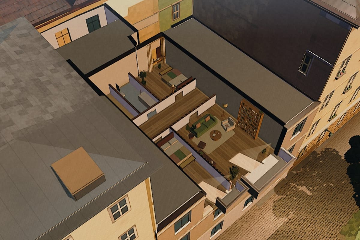
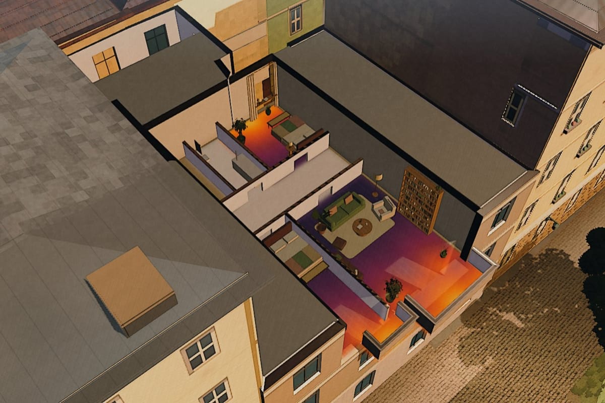
Does the sun reach
your window?
Sun maps stop at the facade — Azima is the only one that keeps going, through the window down to the floor, room by room: for your address, from your floor plan and the measured heights of the neighbouring buildings.
Checking is free · PDF report €9.50 · see a sample (PDF)
One report free:
Azima is the light check for Vienna: a browser tool that calculates, for one address and from the City of Vienna’s official roof model, when direct sun reaches the window — per floor and compass direction and, with a floor plan, per room. The floor plan can arrive as a PDF, OpenImmo, IFC or as an image from the listing; everything is read on your own device.
What a viewing does not show
You see a flat for twenty minutes — on one day, at one time.
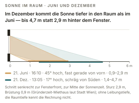
What the sun does there in winter is decided by the buildings opposite — and you cannot see it from inside. Calculated for Schrankgasse 10, floor 2, windows facing west: the same drawing is on page 4 of the sample report.
Sun windows against the measured horizon of the neighbouring buildings · no curtains
What the answer is made of
Vienna, layer by layer.

The same section, 220 × 220 m around Schrankgasse 10 — every layer drawn from the file the tool loads. Azima covers one city, so it can say for each address how many of the shading neighbours have an officially measured eaves height. Where that share is too thin, no number appears.
- 232,661trees with height and crown
- LOD2.1official roof model: eaves and ridge, measured
- 172,296public street lights
- 27,506aircraft positions over 76 days
City of Vienna – data.wien.gv.at, CC BY 4.0 · OpenStreetMap (ODbL) · own ADS-B series · sun position astronomical
The report
Hours of direct sun, for every room.
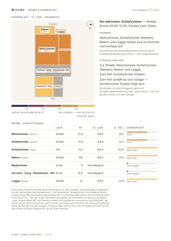
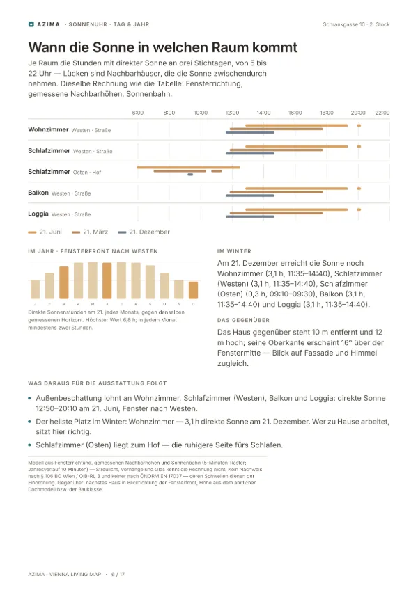
Azima is the only one that turns your floor plan into a 3D room and runs it against the city’s official data — no scan, no appointment, in your browser. Paste the floor plan from the listing — as an image with Ctrl+V, or drop a PDF, OpenImmo export or IFC model. It is read in your browser and never uploaded; then every room gets its own hours of sun, across the year, as a PDF.
Everything on the sheets (12)
How it works, step by step
What Azima does not take from the image is the position of the rooms relative to each other — the drawing shows the recognised rooms with their names and areas in a set arrangement. What the recognition cannot read with confidence stays empty and is said so; no room is invented.
Check your address → · see a sample (PDF) · Pricing: check free, report €9.50, Premium €39 a month
Why Azima exists
After 14 years in Vienna, you see a city differently.
I have lived in Vienna for 14 years. At some point you no longer just see a house. You see the colour of an old façade. The darker plinth. The depth of a window reveal. The tree crowns over a lane. The difference between sun and shade.
You learn not only where Vienna is. You learn what Vienna feels like.
Technically it is fairly easy today to map a city. But a measured city is not yet a city that feels right. I don’t want to build a digital city that only looks correct. I want one that feels like Vienna.
 Lucas Moreira Jakubeitbuilds Vienna Living Map and Azima, in Vienna
From the founding text of Vienna Living Map, of which Azima is a part.
For whom
For agents and developers → · Before you buy a flat → · Which houseplant fits your window? →
Frequently asked
What is Azima?
Azima is the light check for Vienna: a browser tool that calculates, for one address and from the City of Vienna’s official roof model, when direct sun reaches the window — per floor and compass direction and, with a floor plan, per room. Checking is free; the report as a PDF costs €9.50. It is part of Vienna Living Map and runs without an account.
How much direct sunlight does a flat in Vienna get?
It depends far less on the compass direction than on what stands opposite. In a narrow Gründerzeit lane a south-facing flat can be in shade by early afternoon, while a fourth floor in the same house keeps the sun for hours. The light check calculates the real obstruction horizon around one address — for every compass direction the height the sun has to clear — and compares it against the sun’s path for that day.
Which data is this based on?
Building heights come from the City of Vienna’s generalised roof model (LOD2.1, CC BY 4.0) — eaves and ridge, measured, not estimated. Where that is missing, an OpenStreetMap entry counts. Terrain comes from the Copernicus elevation model, the sun’s position from astronomy. Nothing is guessed.
What happens when the data is not good enough?
Then no number appears — only the reason and the coverage figure. An invented hour of sunshine is worse than no answer, because afterwards nobody believes the correct one either.
Does the floor matter?
A lot. Sun maps stop at the house wall; here the calculation runs up the facade. In a deep lane the low winter sun never reaches the ground floor but still clears the neighbours’ roofs higher up — that difference is measured from the same real building heights, and the check says whether it exists at this address.
Can I upload my floor plan?
Yes — and it stays on your device. Drop or paste the PDF of the sales plan, an OpenImmo export, an IFC model or an image of the plan onto the page: it is read in the browser, room by room, with a check that the areas add up to the stated total. After that the check knows the rooms and calculates the hours of sun for each date across the year. There is no upload, no endpoint, no account. You can verify it in the network tab: nothing leaves.
Can I paste a floor plan from willhaben?
Yes, as an image. Copy the floor plan in the listing or save a screenshot and paste it into Azima with Ctrl+V (Mac: Cmd+V) — or drop the image file onto the drop zone. willhaben is only an example here: any listing image or scan takes the same path, and there is no connection to any portal. The image is read on your device and never uploaded; afterwards the recognised rooms can be corrected.
How accurate are rooms read from an image?
Room names are read by text recognition in the browser. Where the square metres are legible in the image, they count. Where the digits are too small — the rule for screenshots from listings — the rooms are measured from the drawing as fields between the walls and converted to square metres via the stated floor area of the listing. In testing, large rooms came within a few percent of the plan figure, small closets considerably further off; the result says so, and under “Stimmt etwas nicht? Räume korrigieren” (the correction panel; the tool speaks German) every figure can be changed. The position of the rooms relative to each other is not taken from the image.
Can I save the result?
Yes, as a real PDF. From the light check a short sheet: address and hours, the measured horizon drawn as a roofline with the sun’s path across it, the course of the year, the sun load per room, the surroundings, aircraft noise, the data coverage and the limits of the calculation. From the stage, in addition, the report of about 17 pages. Both are generated in the browser, so nothing is sent anywhere. The limits travel with it on purpose: a sheet gets passed on and later stands without the page that explained it.
Is my address sent anywhere?
To OpenStreetMap, for the neighbouring buildings — and nowhere else. Nothing travels back to this site; the result stays on your device. You can check that in the network tab.
What does it cost?
Checking costs nothing — no account, no sign-up, no tracking. The report as a PDF with your floor plan costs €9.50 (beta price, €19 after the beta) once; Premium for agents and developers €39 a month, reports without a limit. Free preview: every page, hours for one room on one day. Vienna Living Map stays free.
Sources: City of Vienna — generalised roof model LOD2.1 (CC BY 4.0) · OpenStreetMap contributors (ODbL) · Copernicus elevation model · sun position calculated astronomically. This is a calculation, not an expert opinion: it says nothing about your curtains, the courtyard side or a balcony above your window. Not a certificate under § 106 of the Vienna Building Code / OIB Guideline 3 and none under ÖNORM EN 17037 — their thresholds serve as orientation.
Was something missing? One line to [email protected] is enough.
Check for free →